This blog post highlights the current challenges in accessing and utilizing soil data in Kazakhstan, specifically concerning the limited data available in public international databases.
The lack of information hampers the agricultural industry’s ability to make informed decisions regarding land value and potential for development throughout the nation.
The Strategy to Achieve Carbon Neutrality of the Republic of Kazakhstan until 2060 (1) states: “Improper handling of soils in agriculture (failure to observe crop rotation, insufficient and untimely fertilization, and so on) has led to a decrease in the level of humus in soils, which continues to decline from year to year; accordingly, the ability of soils to capture carbon dioxide from the atmosphere and deposit it is also decreasing.”
In 2023, Kazakhstan and UNDP produced the Eighth National Communication and Fifth Biennial Report of the Republic of Kazakhstan to the UN Framework Convention on Climate Change (2), clearly outlining the importance of soil management-“In cases where the use of a land plot or its part has led either to a significant deterioration of the fertility of agricultural land or to environmental damage, the owner of the land plot or the land user shall be obliged to eliminate the damage in accordance with the legislation of the Republic of Kazakhstan.”
According to paragraph 3 of Article 228 of the Ecological Code (3), “lands are subject to protection from soil degradation, depletion, damage, and deterioration (wind erosion, desertification, etc.)”
Article 238 of the Ecological Code states that “individuals and legal entities shall preclude degradation and depletion of soils in their land use activities”.
Of Kazakhstan’s total countrywide emissions of 401.6 MTCO2e (2), the LULUCF sector accounted for 40.7 MT/year of emissions, with two-thirds from livestock and one-third from arable pastures.
FAO GSOCSeq, a country-wide ROTHC model, estimated in 2023 that under an ideal sustainable soil management scenario (SSM3), soils can sequester 45.2MT per year, a reversal from the current rate of loss of 32 MT per year, resulting in overall mitigation of 77.2 MT per year.
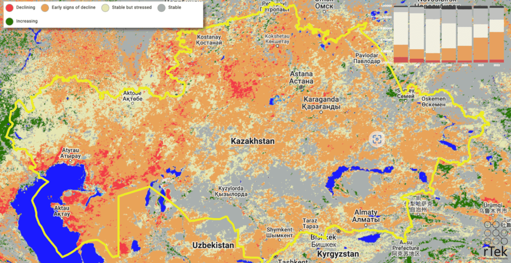
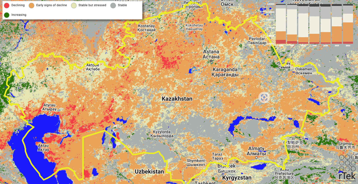
The percentage of stable soils has declined from 57% in 2016 to just 22% in 2022. Soils in “early signs of decline” have increased from 22% to over 48%. The most decline is occurring in areas with the highest current agricultural production, in North Kazakhstan, South-East, and Aktobe region.
Soil Sequestration potential is concentrated mostly in four oblasts:
- Akmola – 15.2 MT/yr,
- North Kazakhstan – 10.5 MT/yr,
- East Kazakhstan – 11.3 MT/yr,
- Almaty – 10.9 MT/yr
Capacity for Measuring Soil Baselines
Many countries measure soil baselines at a much higher level of detail than Kazakhstan. 160 countries, to be precise. But Kazakhstan has the capacity.
Current Status of Soil Data in Kazakhstan:
Our primary sources of soil data are research institutions, government reports, and international databases, each with its limitations.
Among the international open databases, the International Soil Reference and Information Centre (ISRIC) is the only one that avails its data to international scientists, however, the current scope of coverage renders it unfit for its intended use.
Kazakhstan is ranked 160th in the density of carbon samples (hectares per sample), behind Russia by 5 times, Uzbekistan by 20%, and practically all other countries that have ongoing LUCLUCF sector projects.
Industrial and scientific users, (like Boomitra, a carbon credits issuer based in San Francisco), still rely on this database to make investment decisions, posing a severe risk to the development of Kazakhstan’s agricultural industry.
Who is ISRIC?
ISRIC (International Soil Reference and Information Centre) is an independent, nonprofit organization that was established in 1966 by the Food and Agriculture Organization (FAO) and the International Soil Science Society (ISSS), funded by the Government of Netherlands.
Its mission is to serve the international community with information about soils, land resources, and their sustainable management. ISRIC is recognized as the world's leading center for soil information, with a focus on the development and dissemination of global and regional soil databases, such as the popular SoilGrids.org geoportal. The organization provides access to soil data to scientists and policymakers worldwide and supports research and capacity building in soil science.
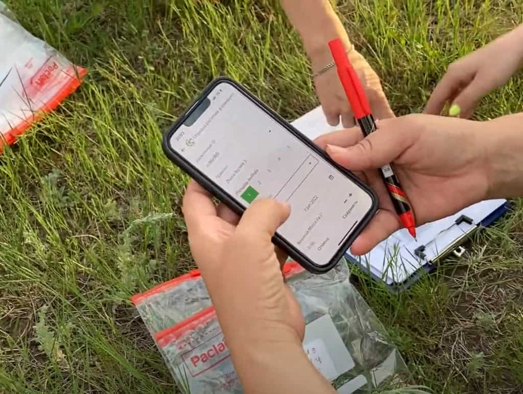
ISRIC currently hosts only 52 soil samples from Kazakhstan, graciously provided by a project by Nazarbayev University in 2017-18. This number is far from sufficient for constructing reliable, high-resolution soil property maps at a country-wide level, considering Kazakhstan’s vast land area.
Top Soil Physical and Chemical Properties in Kazakhstan across a North-South Gradient
Nazarbayev University, Nature, 2018
DOI: 10.1038/sdata.2018.242
2018 Nature, Top Soil Physical and Chemical Properties across a North-South Gradient (pdf)
Another study was performed from 2001-2005 in Shortandy (7915 ha), a collaboration between Baraev Institute and researchers at Kyoto University. They found a sequestration rate above the baseline of up to 1 MgC/ha/yr, based on barley and wheat crop rotation.
Influence of crop rotation system on the spatial and temporal variation of the soil organic carbon budget in northern Kazakhstan
Tanaka et. al, Kyoto University, Baraev Institute, 2008
DOI: 10.1111/j.1747-0765.2007.00217.x
Influence of crop rotation system on the spatial and temporal variation of the soil organic carbon budget in northern Kazakhstan (pdf)
Takata Study Plots.kmz
And in 2021, based on the ISRIC available dataset, FAO and the Kazakhstan Ministry of Agriculture provided a national submission to the GSOCSeq (Global Soil Organic Carbon Sequestration) map. Although a positive step, this model disagrees with the Tanaka 2008 study by over 300%, underestimating carbon sequestration potential.
FAO GSOCSeq Technical Reports
Using the FAO GSOCSeq data, average potential SSM3* sequestration rates are calculated per region. The predicted sequestration rates are very low, around 0.07 t/ha/yr of carbon sequestration. In North Dakota, for example, (in similar climates) observed sequestration rates are closer to 0.3 t/ha/yr.
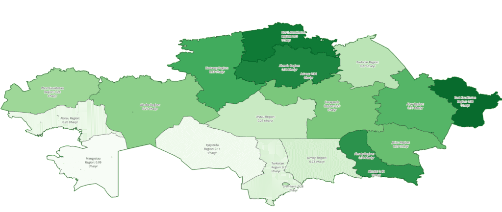
Given this low sequestration forecast, with the conversion rate of 3.6663 tCO2e/tC, we see that each hectare can sequester around 0.25 tCO2e/year, with the highest areas in east Kazakhstan.
SSM3 (Sustainable Soil Management Scenario 3)
This map represents the projected soil organic carbon stocks (in t C ha-1) in 2040, after 20 years of implementation of sustainable soil management (SSM) practices that generate a 20 percent increase in carbon inputs (Scenario 3), at a soil depth of 0-30 centimeters.
2.9x Correction Factor
The Takata 2008 study observed significantly higher soil carbon sequestration rates, and we can directly compare the sequestration rates observed in the soil to the predicted rates by GSOCSeq.
Doing this overlay comparison yields a correction factor of roughly 290%, which might apply to North Kazakhstan Chernozems (Black Soils) only, however unknown at this time.
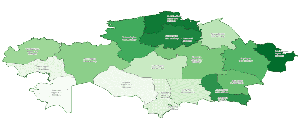
If the 2.9x correction factor is applied to all of Kazakhstan, a more reasonable soil sequestration rate is predicted on the site by GSOCSeq (corrected). This provides an estimate of 0.95 tCO2e/ha/yr, for the Tanaka study site, within their local experiment’s error bounds.
Projecting Optimistically
Projecting this to other sites in the region (above), a prediction between ~0.8 - 1.2 tCO2e/ha/yr is possible, which is within the empirically expected range in this climate and soil type.
Issues with differing baseline measurements and assumptions
(See FAO Technical Report for specific deep-dives into these points below)
- Soil (BAU) carbon levels are dynamic, not static. The transport pathways between atmosphere GHGs, and surface/ subsoil water are very large and can be increased even more by anaerobic conditions and methanotrophic organisms.
- Climate-based SOC losses (due to drying, salinization, and decrease of biodiversity due to extreme weather events) may significantly exceed any sequestration even in the best-case scenarios (at least on the 100-year time scale) making SSM practices more like REDD+ in that they are preventing loss, rather than necessarily gaining carbon. Verra’s VM0042 does appear to account for this, as a declining baseline-declining SSM would still yield carbon credits.
- In increasing SOC systems, labile sinks require constant “feeding pressure” with organic matter to activate conversion to longer-term SOC storage sinks (like mineralization and aggregate adsorption). These sinks can theoretically become saturated, slowing the SOC sequestration rates over time and requiring higher and higher feeding pressures. On the balancing side, increasing biodiversity has an accelerating effect on sequestration rates. Due to the complexity of these interactions, it is almost impossible to predict which scenario will apply to a given site until empirical trials begin.
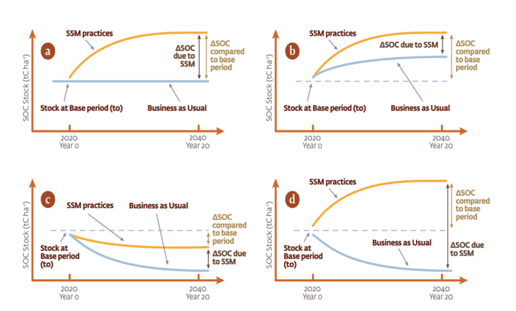
4. Comparing previous experiments to plans is very difficult because baseline measurement practices differ from experiment to experiment. The worst-case scenario for generating carbon credits is also quite likely due to traditional grazing practices (B). Because the BAU (Business as Usual) baseline is approaching a sequestration limit, the annual increase in the difference between SSM and baseline trends towards zero, meaning that carbon credits could not be produced from the same land at the same rate in perpetuity, but only temporarily, although SSM practices would need to continue for a very long time to facilitate the transfer from short to long term storage.
Some current crediting mechanisms (BCarbon, Gold Standard) don’t account for baseline scenarios C or D, which, similar to REDD+, utilize SSM to counteract or slow losses under BAU.
Risks of Current AI-Driven Interpolation Methods:
The scarcity of soil data has forced scientists and policymakers to rely on artificial intelligence (AI)–driven interpolation methods for estimating soil properties across larger geographic regions.
What is Random Forest Interpolation?
Random forest interpolation is a machine learning technique used to estimate unknown soil properties across larger geographic regions by training on a subset of available data. The algorithm creates a decision tree for each subset of the data and combines them to make a prediction. This method is commonly used when working with sparse soil data.
Limitations of Random Forest Interpolation
While random forest interpolation can provide some valuable insights, it is not effective when working with sparsely sampled data, especially when the samples are not well distributed and attempting to represent a large area. This is because the model struggles to account for the variations in soil properties across different regions.
When there are many thousands of kilometers between samples, the model may make incorrect assumptions and overgeneralize the data, leading to inaccurate predictions.
In the case of Kazakhstan, the limited soil data available is sparsely distributed across the country. As a result, a random forest interpolation model would not be effective in estimating soil properties at a country-wide level, with accuracies in the low 60% range or worse, similar to a coin toss.
The model would likely produce unreliable or misguided predictions, leading to poor decision-making and potentially disastrous consequences for the agricultural industry and environmental conservation efforts.
Given these limitations, it is essential to prioritize the development of a comprehensive national soil database for Kazakhstan, which would provide accurate and reliable data for scientific research, policymaking, and sustainable agricultural practices.
While current AI-driven methods can provide some valuable insights, there are significant limitations and potential risks, especially when calibrating based on a small number of samples, as is the case with Kazakhstan.
Low Accuracy: With only 52 samples, the AI models may not accurately represent the complex variations in soil properties across different regions of Kazakhstan. This could result in misleading conclusions about soil health and composition.
Increased Uncertainty: Sparse sampling increases the uncertainty of the interpolated maps, leading to potentially unreliable or misguided decision-making, which could adversely impact land use planning, agricultural productivity, and environmental conservation efforts.
Generalization Errors: The AI models might make incorrect assumptions based on limited data, leading to significant generalization errors. Given Kazakhstan’s geographical diversity, these errors could be substantial.
Illustrative Cases for the Application of a Soil Database:
To further highlight the potential benefits of a comprehensive soil database, let’s consider these practical applications:
Optimized Agricultural Practices: With an extensive soil database, AI models can create precise soil property maps.
Farmers can use these to understand their land better, enabling them to choose suitable crops, determine optimal planting times, and apply fertilizers more effectively, thus increasing agricultural productivity while minimizing environmental impacts.
Informed Agricultural Investments: With a comprehensive soil database, agricultural investors can make informed decisions about land acquisition and assess the potential for growing new crops.
This information can also help reduce risks and barriers to entry for industry investors by identifying areas with soil properties that could pose challenges to certain crops.
Sustainable Land Use Planning: Policymakers can use high-resolution soil maps to inform land use policies, helping to conserve environmentally sensitive areas, plan infrastructure projects, and mitigate the impacts of climate change.
Environmental Protection: Conservationists can utilize soil data to monitor soil degradation and biodiversity loss, thereby guiding effective strategies for environmental protection.
The Importance of a National Soil Database:
Given these considerations, it’s clear that a national soil database for Kazakhstan is a necessity. It would provide numerous benefits:
- Consolidated Information: It would gather all soil data into one accessible source, removing unnecessary access barriers for the industry.
- Standardized Data Collection: It would ensure the use of standardized, rigorous methodologies for soil data collection across the country.
- Informed Decision-Making: It would significantly enhance the quality of information available to policymakers, farmers, and scientists.
- Improved Soil Mapping: It would allow for the creation of more accurate and detailed soil property maps, with high-detail AI models, reducing the risk of generalization and uncertainty that current AI models pose.
In conclusion, the development of a comprehensive national time series soil database for Kazakhstan is an urgent need, offering significant potential benefits. It will contribute substantially to sustainable agricultural practices, informed policymaking, and scientific research, while mitigating the risks of current practices, and contributing significantly to the development of the Agriculture sector.

