Introduction
Precise Point Positioning (PPP), Real-Time Kinematic (RTK), and Post-Processed Kinematic (PPK) are all technologies that enable centimeter-level accuracy with satellite navigation. These technologies are critical for producing the highest quality datasets in applications such as surveying, mapping, and asset management.
PPP, RTK, and PPK all use signals from Global Navigation Satellite Systems (GNSS) such as GPS, GLONASS, Galileo, and BeiDou to determine the precise position of a receiver on the Earth’s surface.
PPP uses dual-frequency receivers that receive signals from multiple satellites simultaneously and corrects for atmospheric delays caused by the ionosphere and troposphere.
RTK provides real-time positioning with centimeter-level accuracy by using a reference station that transmits correction data to the receiver in real-time. PPK requires post-processing of the data collected by the receiver using a precise ephemeris and data from a reference station.
In this blog post, we will discuss the differences between PPP, RTK, and PPK, as well as the importance of each technology in producing the highest quality datasets.
We will also discuss the accuracy chaining of these technologies, CORS, and rTek’s approach to combining these technologies for the highest quality datasets.
What is Precise Point Positioning?
Precise Point Positioning (PPP) is a method used to determine the precise position of a receiver on the Earth’s surface. PPP uses signals from Global Navigation Satellite Systems (GNSS) such as GPS, GLONASS, Galileo, and BeiDou to determine the receiver’s position with centimeter-level accuracy.
How PPP Works
PPP uses dual-frequency (L1 + L2) receivers that receive signals from multiple satellites simultaneously. These signals are processed using a precise ephemeris, which is a model of the satellite’s position and velocity. The signals are also corrected for atmospheric delays caused by the ionosphere and troposphere.
Advantages and applications of PPP
PPP can be used in various applications such as surveying, geodesy, and navigation. It is particularly useful in situations where high accuracy is required, such as in precision agriculture, construction, and autonomous vehicles. In addition to these, PPP can also be used in drone scanning and georeferencing images.
With PPP, the precise location of a drone can be determined, making it possible to create highly accurate maps and models of the surveyed area. This is particularly useful in industries such as mining and agriculture, where precision is critical for efficient and effective operations.
Comparison of PPP and non PPP data
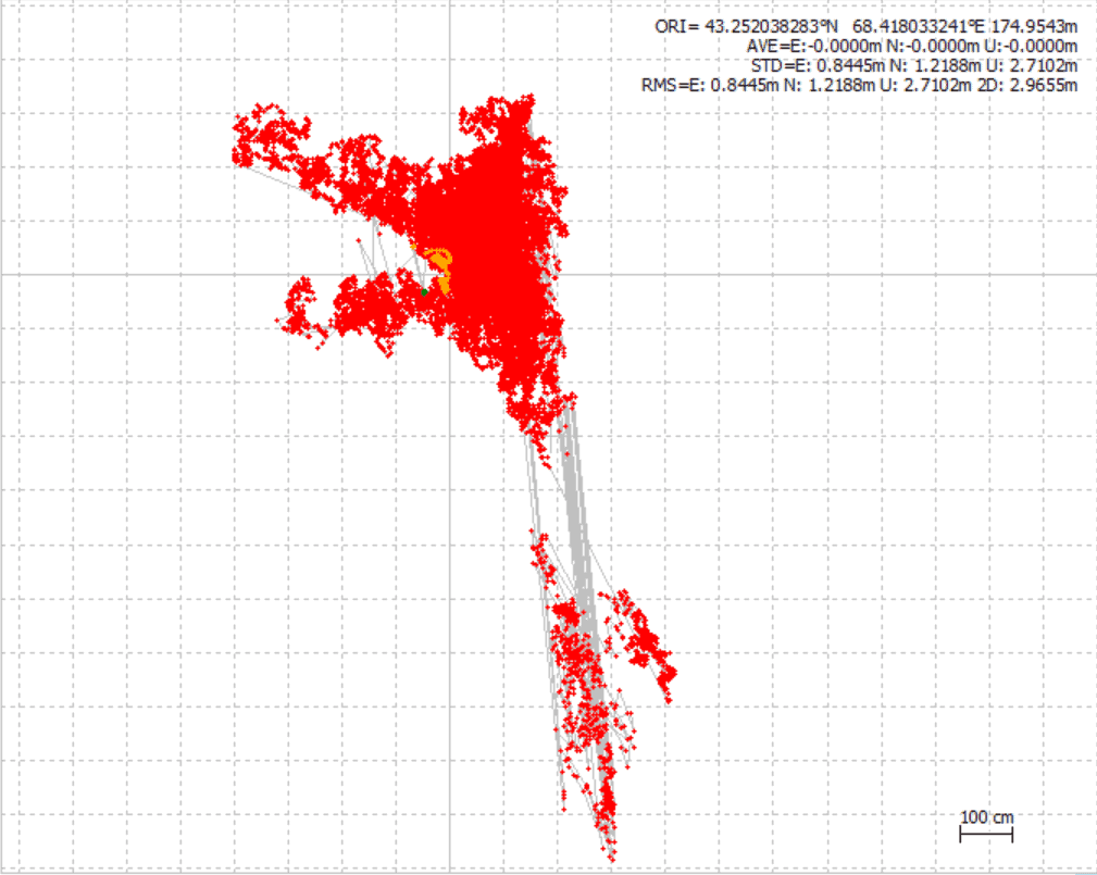
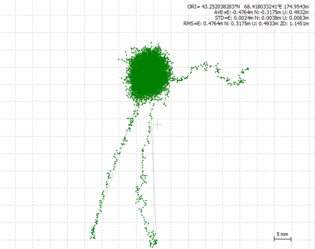
On the left (red), we have the precision of an RTK base station over several hours of recording time. The location of the fixed base station appears to float several meters. This happens whenever the location is not post-processed. The base station appears to move around, although fixed on the ground.
When we introduce PPP post-processing, the base station data becomes much more rigid. Most of the data is clustered within a 1.5 cm point. The small lines to the sides of the point are actual movements when the tripod was initially being set up.
Real-Time Kinematic (RTK)
Real-Time Kinematic (RTK) is a method used to achieve high-precision positioning using Global Navigation Satellite Systems (GNSS) such as GPS, GLONASS, Galileo, and BeiDou. RTK provides real-time positioning with centimeter-level accuracy by using a reference station that transmits correction data to the receiver in real-time.
How RTK Works
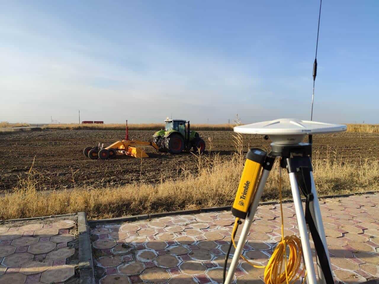
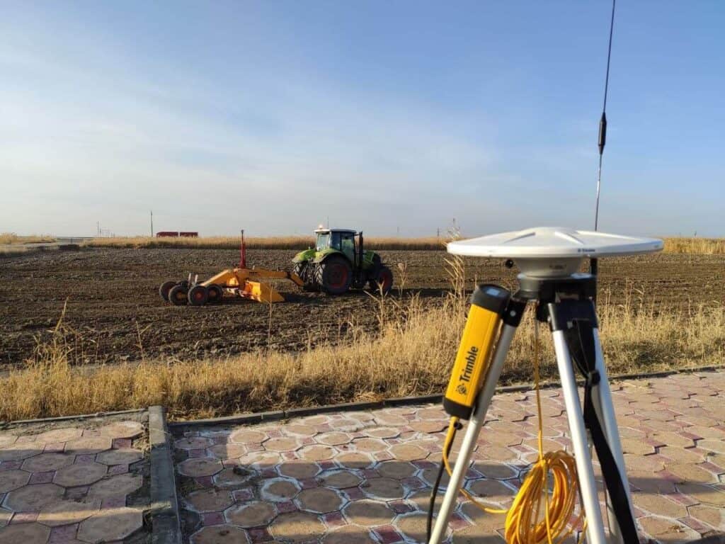
RTK works by using a base station and a rover. The base station is located at a known position and receives signals from multiple satellites. The base station transmits correction data to the rover, which is located at an unknown position and also receives signals from multiple satellites. The rover uses the correction data to correct for errors in the satellite signals and determine its precise position.

Advantages and Applications of RTK
RTK is best suited for applications where real-time positioning is required, such as in agriculture, construction, and surveying. RTK can be used to achieve centimeter-level accuracy in real-time, which is critical for many applications that require precise spatial information.
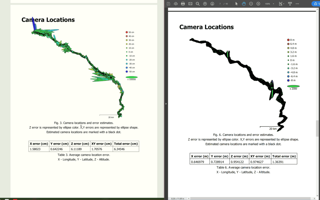
Images taken on a drone for example are processed with trajectory data from the drone to assign geotags with extreme precision, to the millimeter, even including the exact shot angle. The Sensefly eBee X’s SODA 3D camera shoots with an oblique camera that changes angle with each image, so that objects get imagery coverage from four sides, as well as straight-down.
Comparison with PPP and PPK
PPP and PPK provide centimeter-level accuracy, but require post-processing of data. RTK provides real-time positioning with the same level of accuracy, making it a better choice for applications where real-time positioning is required. However, RTK requires a reference station and can be limited by the range of the reference station, while PPP and PPK can be used in remote areas where reference stations are not available.
In summary, RTK is a valuable technology for achieving real-time centimeter-level accuracy with satellite navigation. By understanding the advantages and limitations of RTK, it is possible to choose the most appropriate technology for a given application and achieve the highest quality datasets.
Post-Processed Kinematic (PPK)
Post-Processed Kinematic (PPK) is a method used to achieve high-precision positioning using Global Navigation Satellite Systems (GNSS) such as GPS, GLONASS, Galileo, and BeiDou. PPK requires post-processing of the data collected by the receiver using a precise ephemeris and data from a reference station.
Definition of PPK
PPK is a method used to achieve high-precision positioning using GNSS data. PPK requires post-processing of data collected by a receiver using a precise ephemeris and data from a reference station.
How PPK Works
PPK works by collecting data from GNSS signals and storing it in a receiver. This data is then post-processed using a precise ephemeris and data from a reference station to determine the position of the receiver with high accuracy. PPK can be used to achieve high accuracy in remote areas where real-time positioning is not possible, making it a valuable tool in various applications.
Advantages and Applications of PPK
PPK is best suited for applications where post-processing is acceptable and high accuracy is required. It can be used in various applications such as surveying, mapping, and asset management. PPK is particularly useful in remote areas where real-time positioning is not possible, but high accuracy is still required.
Comparison with PPP and RTK
PPP and PPK provide centimeter-level accuracy, but require post-processing of data. RTK provides real-time positioning with the same level of accuracy, making it a better choice for applications where real-time positioning is required.
However, RTK requires a reference station and can be limited by the range of the reference station, while PPP and PPK can be used in remote areas where reference stations are not available.
In summary, PPK is a valuable technology for achieving high-precision positioning using GNSS data. By understanding the advantages and limitations of PPK, it is possible to choose the most appropriate technology for a given application and achieve the highest quality datasets.
Differences Between PPP, RTK, and PPK
PPP, RTK, and PPK are all technologies that enable centimeter-level accuracy with satellite navigation. However, each technology has its own advantages and limitations depending on the specific application and requirements.
Comparison of accuracy
PPP, RTK, and PPK all provide centimeter-level accuracy, but the accuracy of each technology varies depending on the specific application. PPP can achieve high accuracy in post-processing, while RTK provides real-time positioning with the same level of accuracy. PPK requires post-processing, but can be used to achieve high accuracy in remote areas where real-time positioning is not possible.
Calculating Photogrammetry Precision
Comparison of equipment requirements
PPP requires dual-frequency receivers that can receive signals from multiple satellites simultaneously.
RTK requires a reference station that transmits correction data to the receiver in real-time, but can use a single frequency receiver (L1) GNSS for the rover, which is much less expensive. PPK requires post-processing of the data collected by the receiver using a precise ephemeris and data from a reference station, which can require additional software or run into compatibility problems across manufacturers.
Manufacturers like Trimble and Leica have their own processing software, which locks users into their ecosystem.
Precise Point Positioning (PPP)
- Can achieve centimeter-level accuracy
- Can be used in remote areas where reference stations are not available
- Can be used for various applications such as surveying, geodesy, and navigation
- Particularly useful in situations where high accuracy is required, such as in precision agriculture, construction, and autonomous vehicles
- Requires dual-frequency receivers
- Requires post-processing of data
- Requires separate calibration and acquisition periods for PPP and rover operation
- Processing time can vary depending on the amount of data collected
- Can be affected by environmental factors such as ionosphere and troposphere
Real-Time Kinematic (RTK)
Pros
- Provides real-time positioning with centimeter-level accuracy
- Best suited for applications where real-time positioning is required
- Can use a single frequency receiver (L1) for the rover, which is much less expensive than dual-frequency receivers used in PPP
Cons
- Requires a reference station
- Can be limited by the range of the reference station’s radio or GSM connection
- Not suitable for remote areas where reference stations are not available
Post-Processed Kinematic (PPK)
Pros
- Can achieve high accuracy in remote areas where real-time positioning is not possible
- Best suited for applications where post-processing is acceptable
Can be used in various applications such as surveying, mapping, and asset management - Can be used without a radio or GSM connection between rover and base station
Cons
- Requires post-processing of data
- Can be affected by environmental factors such as ionosphere and troposphere
- Requires additional software or can run into compatibility problems across manufacturers
Overall, each technology has its own advantages and limitations. By understanding these, it is possible to choose the most appropriate technology for a given application and achieve the highest quality datasets.
The equipment requirements for each technology vary depending on the specific application and requirements.
Comparison of processing time
PPP and PPK both require post-processing of data, which can take time depending on the amount of data collected. RTK provides real-time positioning, which means that there is no processing time required.
Comparison of use cases
PPP is particularly useful in situations where high accuracy is required, such as in precision agriculture, construction, and autonomous vehicles. RTK is best suited for applications where real-time positioning is required, while PPK is better suited for applications where post-processing is acceptable.
In summary, each technology has its own advantages and limitations depending on the specific application and requirements. By understanding the differences between these technologies, it is possible to choose the most appropriate technology for a given application and achieve the highest quality datasets.
What is the difference between RTK and PPK, and RTK-CORS?
Rover-corrections systems like RTK and PPK can sometimes be confused. The two base corrections types (RTK and PPK) can also be used with local base stations or with remote stations, up to 15 km away.
RTK (Real-Time Kinematic) and PPK (Post-Processed Kinematic) are two methods used to achieve high-precision positioning using GNSS data. Both methods use dual-frequency receivers and precise ephemerides to determine the position of the receiver.
RTK provides real-time positioning with centimeter-level accuracy by using a reference station that transmits correction data to the receiver in real-time. PPK, on the other hand, requires post-processing of the data collected by the receiver using a precise ephemeris and data from a reference station.
RTK-CORS is a combination of RTK and CORS, which provides real-time positioning with centimeter-level accuracy without the need for a local reference station. Instead, the receiver uses a network of CORS stations to receive correction data in real-time, over mobile data networks or even long range radio link.
Overall, RTK is best suited for applications where real-time positioning is required, while PPK is better suited for applications where post-processing is acceptable. RTK-CORS provides real-time positioning with the same level of accuracy as RTK, but without the need for a local reference station.
What is the difference between PPP and CORS?
CORS (Continuously Operating Reference Station) is a network of GNSS receivers that provide real-time positioning data for a specific region. In contrast, PPP is a post-processing technique that requires data collected by a single receiver over a period of time.
CORS stations are typically located at known positions and provide a reference for real-time positioning. PPP, on the other hand, does not require a reference station and can be used in remote areas where CORS stations are not available.
Another difference is that CORS provides real-time positioning, while PPP requires post-processing of data and therefore has a longer processing time.
Overall, both PPP and CORS are valuable techniques for determining precise positions using GNSS, but they have different advantages and limitations depending on the specific application and requirements.
Precise Point Positioning is a technique for determining the precise position of a receiver on the Earth’s surface with centimeter-level accuracy using signals from GNSS. It is a valuable tool in various applications where high accuracy is required.
When processing CORS data, it’s beneficial to use PPP to double-check the CORS station’s coordinates. Some CORS stations don’t have PPP-verified locations, especially in Kazakhstan, so a verification step needs to be done:
- Download the CORS data from the station
- Format a sample for PPP processing
- Process the sample data to obtain coordinates
- Process PPK rover data using the known coordinates obtained from the PPP sample.
rTek uses PPP, CORS, and RTK together to produce the highest quality datasets
rTek uses a combination of PPP, CORS, and RTK (Real-Time Kinematic) to provide the highest quality datasets for our clients. PPP is used for post-processing data collected by our mobile mapping systems and UAVs. CORS is used as a reference station for our RTK and PPK systems, which provide real-time centimeter-level accuracy.
By combining these techniques, we are able to provide highly accurate and precise datasets for applications such as surveying, mapping, and asset management. Our integrated approach also allows us to operate in remote areas where CORS stations may not be available.
rTek uses a combination of PPP, CORS, and RTK to provide the highest quality datasets for our clients. This integrated approach allows us to provide highly accurate and precise datasets for various applications, even in remote areas where CORS stations may not be available.
- Using the least number of chained sources possible
- Operating in remote areas where CORS stations may not be available
Additional Information
To give you more of the whole picture, we want to provide some additional details you might need if you’re deciding which methodologies to use for your GNSS data.
Accuracy Chaining
Accuracy is added together when measurements are combined, or when chaining sources like PPP and PPK. The accuracy of each measurement is determined by various factors, such as the quality of the equipment and the environment in which the measurement was taken. When combining measurements, the accuracy of each measurement is added to determine the overall accuracy of the result.
When chaining sources, such as PPP and PPK, the accuracy of each source is added to determine the overall accuracy of the result.
For example, if PPP provides a position with an accuracy of 2 cm and PPK provides a position with an accuracy of 3 cm, the overall accuracy of the result would be 5 cm.
It’s important to note that accuracy is not always additive. In some cases, combining measurements or sources can actually decrease the overall accuracy of the result. This can happen if the measurements or sources are not compatible, or if there are errors in the data.
In order to ensure the highest accuracy possible, it’s important to use reliable equipment and techniques, and to carefully consider the compatibility and accuracy of each measurement or source when combining them.
rTek uses the least number of chained sources possible when creating our geodetic quality datasets. For example, it might be beneficial to use only a local PPP base station, and then PPK from a rover, when the baseline distance is too far to a base station.
In PPK (Post-Processed Kinematic) and RTK (Real-Time Kinematic), the baseline refers to the distance between the rover receiver and the reference station receiver. The baseline distance is an important factor in determining the accuracy of the position solution. A longer baseline distance can result in reduced accuracy due to factors such as signal attenuation and multipath interference. To mitigate this, it's important to carefully select the location of the reference station and to use techniques such as atmospheric correction to improve the accuracy of the position solution.
With Leica Smartnet, the baseline adds 1 mm of error for every thousand meters away from the base station, plus a baseline error of 1.5 cm. Baselines in Kazakhstan can easily be more than 15 km from a survey site, making these CORS mostly useful for in-city work only.
Leica Smartnet CORS
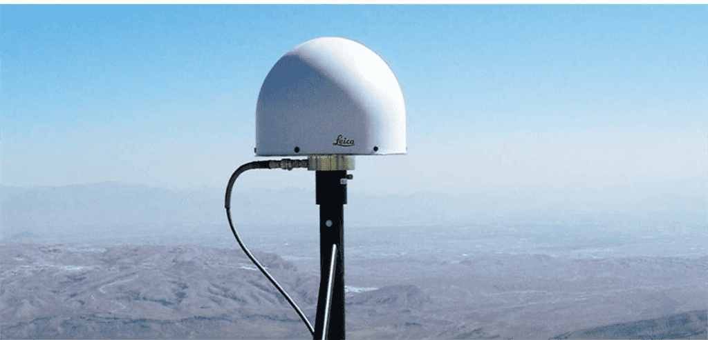
rTek Uses Leica Smartnet CORS for the Highest Quality Datasets
Leica Smartnet is a network of CORS stations that provides high-accuracy positioning data in real-time. It is used in surveying, construction, and other applications where high-precision positioning is required.
Smartnet is operated by Leica Geosystems, a Swiss company that specializes in measurement and imaging technologies. The Smartnet network covers many countries around the world including Kazakhstan, and provides reliable and accurate positioning data to users. However, it’s not available in every city.
By using Smartnet in conjunction with PPP and RTK techniques, rTek is able to provide highly accurate and precise datasets for various applications, even in areas where CORS stations may not be available.
Other CORS networks
Depending on your RTK/PPK equipment manufacturer, you might need a different CORS network, for example, Leica Smartnet works with RTK only with Leica Geosystems equipment, however PPK data is cross-platform compatible.
If you have Trimble hardware, you might use the Trimble VRS network, which provides real-time kinematic (RTK) data for high-precision positioning. The Trimble VRS network covers many areas around the world, and provides reliable and accurate positioning data to users.
We also tried using Trimble’s RTX service with our AgGPS542, but couldn’t get it to work. Fortunately, Trimble was able to provide an unlock service to allow the unit to interoperate with PPK, which is often required on hardware.
Software Unlocks
When choosing hardware, unless you’re getting same-brand for everything, you typically need to make sure it is compatible with an interoperable standard for GNSS data, in order for PPP and PPK to work. That interoperable standard is called RINEX.
What is RINEX?
RINEX (Receiver Independent Exchange Format) is a standard data format used for exchanging GNSS data between different receivers and software applications. It defines a common format for the raw data collected by GNSS receivers, which can be used by different software applications for post-processing and analysis.
Interoperability between devices is important in the context of PPK and PPP because it allows different receivers and software applications to work together and exchange data in a standardized format. This enables users to choose the best equipment for their needs and to use different equipment and software applications together to achieve the highest quality datasets.
In order to achieve interoperability between devices, it is important to use receivers and software that support the RINEX format and to ensure that the data collected by different devices is compatible. This can be achieved by carefully selecting equipment and software that are compatible with each other and by testing the compatibility of different devices and applications before using them together.
Overall, RINEX is an important standard in the context of PPK and PPP because it enables different devices and software applications to work together and exchange data in a standardized format, allowing users to achieve the highest quality datasets.
By using the appropriate CORS network like Leica Smartnet, which supports RINEX output, in conjunction with PPP, RTK, and PPK techniques, it is possible to achieve highly accurate and precise datasets for various applications, even in areas where reference stations may not be available.
Final Takeaways
PPP, RTK, and PPK are critical technologies for achieving centimeter-level accuracy with satellite navigation. Each technology has its own advantages and limitations, and it is important to understand the differences between these technologies in order to choose the most appropriate technology for a given application.
By combining these technologies with CORS networks, it is possible to achieve the highest quality datasets for applications such as surveying, mapping, and asset management.
rTek's integrated approach allows us to operate in remote areas where reference stations may not be available, and to provide highly accurate and precise datasets for our clients..
In the future, we can expect to see even more advanced technologies that enable even higher levels of accuracy and precision with satellite navigation. These technologies will continue to transform industries and enable new applications, and rTek will be at the forefront of these developments.

