In the vast steppes of Kazakhstan, where agriculture meets the challenge of climate change, understanding the soil beneath our feet is more crucial than ever. Soil sampling methodologies aren’t just technical jargon—they’re the foundation for sustainable farming, carbon sequestration projects, and environmental conservation.
At rTek, we’re pioneering advanced soil sampling techniques tailored to Kazakhstan’s unique landscapes, helping farmers, researchers, and project developers unlock the potential of their land.
What is Soil Sampling?
Imagine your farm as a giant puzzle. Traditional methods might grab random pieces that don’t fit together, but what if you could strategically select them to get the full picture?
Soil sampling is the process of determining the composition of your soil by selecting and removing a small amount of the soil that represents your land as a whole.
However, it’s not that simple – soil properties are not consistent everywhere. In fact, there is so much variety that a sample taken just 30 meters away from another might have completely different properties.
One solution is to take random points and take an average. Such a method is representative of the whole, but provides little insight into local variations. On top of that, it requires a very high number of sampling points to be accurate. This is due to small hills and valleys or even soil compaction, which leaches and concentrates nutrients asymmetrically. Water is forced to flow sideways rather than infiltrating downwards, taking nutrients on a meandering path, and your random samples have a lot of variation, ignoring these fine differences.
Stratified Random Sampling
That’s where stratified random sampling comes in—a smart, efficient way to assess soil health, measure organic carbon, and support carbon credit initiatives. It uses mapping to control for topography and differences in soil management, allowing the location of ideal samples to be chosen. This preserves both representativeness and mapping accuracy.
In this comprehensive guide, we’ll break down what soil sampling is from a beginner’s perspective, why stratified random is superior for soil carbon testing in Kazakhstan, and how rTek implements it step by step.
Whether you’re a farmer curious about regenerative practices or a developer eyeing Verra-compliant projects, this blog post will equip you with the knowledge to make informed decisions.
By the end, you’ll see why rTek is leading the charge in soil sampling methodologies in Kazakhstan, blending cutting-edge technology with local expertise. Let’s dig in—literally!
Why Soil Sampling Matters: The Basics Explained
Soil sampling is like taking a health checkup for your land. It involves collecting small amounts of soil from different spots to analyze what’s inside—nutrients, organic matter, pH levels, and, crucially for today’s climate-focused world, soil organic carbon (SOC).
SOC is the carbon stored in the soil from plant roots, microbes, and decomposed organic material. In Kazakhstan’s chernozem-rich northern regions, soils can hold impressive amounts of carbon, often 100+ tons of carbon per hectare in the top 30 cm.
We don’t think of the pasture as just un-arable dirt; it’s a natural carbon sink that can help combat global warming through sequestration—trapping carbon in the ground naturally using the most prevalent forms of life on earth: grass and subsoil microbes.
From a high-level view, think of soil as a living ecosystem. It’s not uniform; it varies due to factors like rainfall, crop rotations, and terrain.
Poor sampling can lead to inaccurate data, misleading you about fertilizer needs or carbon storage potential. For instance, in sunflower-based rotations common in Kazakhstan, conservative tillage preserves soil structure, but bare periods after harvest limit carbon inputs. Accurate sampling reveals these nuances, enabling better decisions.
In carbon sequestration projects, precise sampling is non-negotiable. Standards like Verra VM0042 require reliable baselines to measure changes over time. Without it, you can’t verify gains—say, 0.5-0.8 tons of carbon per hectare per year from introducing cover crops. With credits valued at $25+ each, the difference represents potentially millions of dollars over the project, so it has to be right.
rTek’s methodologies ensure compliance, turning your farm into a verifiable asset for carbon markets like Gold Standard or Puro Earth.
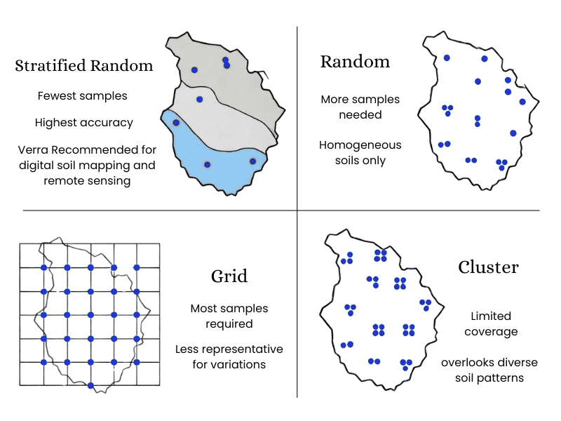
But how do you sample effectively? Enter the world of sampling designs. Traditional grid patterns, where you sample at fixed intervals like a checkerboard, seem straightforward. However, they often miss variations, leading to biased results.
Verra guidelines suggest that grids from vehicle-mounted tools (which take tiny samples) aren’t representative for complex soils. That’s why stratified random sampling shines—it’s like using a map to target key areas intelligently.
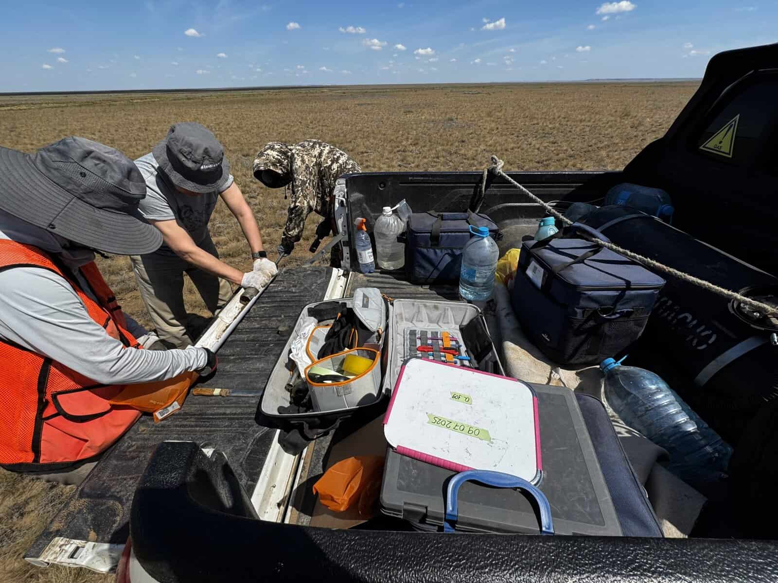
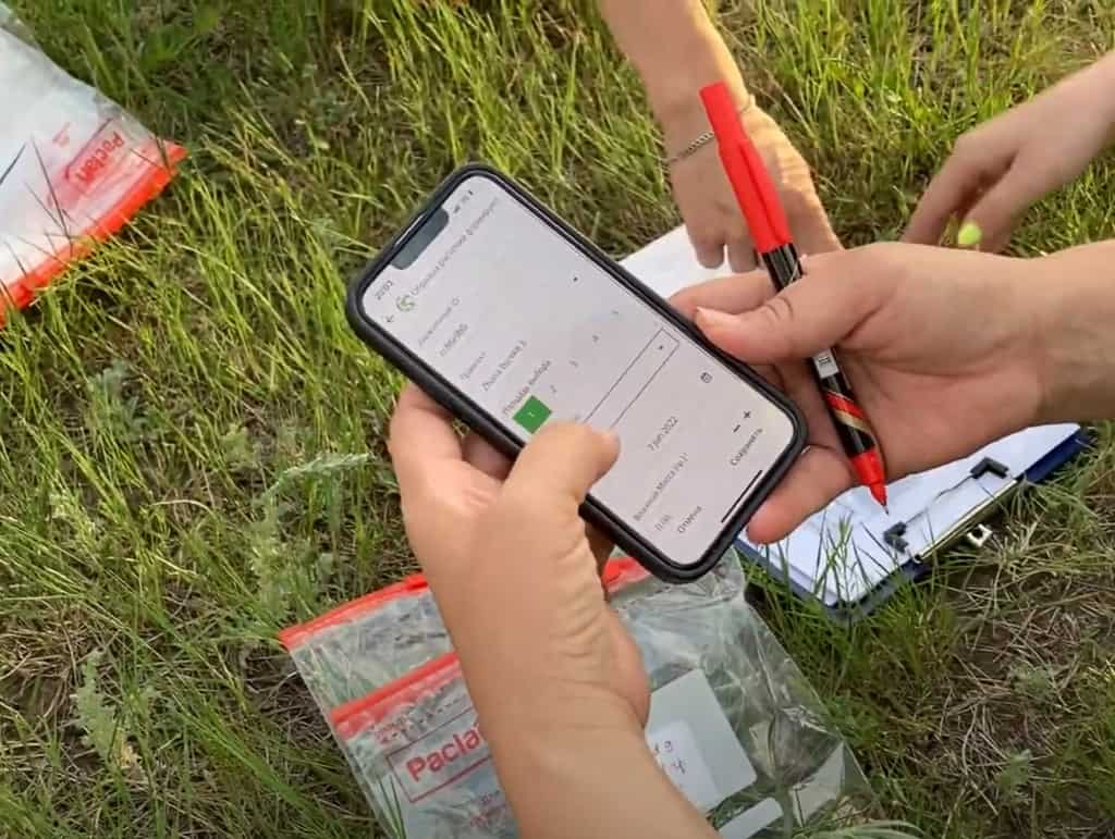
Image: rTek’s team conducting intact-core soil sampling in Aktobe Region
Grid vs. Stratified Random Sampling: Why We Choose Smarter Methods
Let’s compare the two main approaches in simple terms. Grid sampling is like throwing darts blindly—you divide the field into a grid and sample at each intersection, often using automated vehicles that poke small holes. It’s easy but flawed.
In uneven terrain like Kazakhstan’s rolling steppes, grids might over-sample flat areas and under-sample slopes, skewing data. Verra’s methodologies, like VM0032 and VM0042, recommend against it for carbon projects. Grid sampling doesn’t capture variability well, potentially inflating uncertainty and reducing credit eligibility.
Stratified random sampling, on the other hand, is like a guided treasure hunt. Before taking samples, you already come with a good idea of where the nutrients and carbon are concentrated.
Digital Soil Mapping (DSM) helps even further by using AI to learn the patterns in the soil. rTek uses Verra’s new VT0014 tool, in collaboration with Perennial, to make the most accurate maps of soil carbon that are possible. DSM is especially in geographies like Kazakhstan that have a low number of carbon samples to-date.
With DSM, you can generate accurate maps of soil before taking thousands of samples, and every sample you do take trains the AI to make it even smarter.
You first divide the land into “strata”—groups based on similar characteristics, such as vegetation health or soil type. Then, within each group, you randomly select spots to sample. This ensures every part of the puzzle is represented proportionally, reducing errors and costs.
From an everyday perspective, imagine baking a cake. Grid sampling tastes random bites; stratified checks the crust, filling, and icing separately for balance. In soil terms, strata might be based on satellite data showing greener vs. drier patches. This method lowers the coefficient of variation (a measure of data spread) to around 27-30% in rTek’s projects, meaning more reliable averages.
rTek opts for stratified over grid because it’s efficient for digital soil mapping (DSM)—creating virtual maps of soil properties. Verra’s VT0014 tool, which we’re among the first globally to use via our Perennial partnership, leverages AI to predict strata. This isn’t sci-fi; it’s practical. For example, in a multi-field project, we group areas by shared traits rather than treating each field separately, saving time without sacrificing accuracy.
The benefits? Lower uncertainty in SOC estimates, crucial for carbon sequestration. In Kazakhstan’s chernozem soils, where stocks range 50-120 tC/ha, precise mapping reveals high-potential zones for practices like legume rotations, boosting yields by 10-20% while sequestering carbon.
Accuracy isn’t worth it if it comes at a much higher cost. But stratified random sampling and DSM are actually cheaper, not more expensive.
Other sampling designs might be easier to design, but in the long run, they’re more expensive.
- Due to the higher number of samples required, random sampling campaigns can take 20-30% longer to complete, and weather can extend this even further.
- Random and grid sampling distribute points evenly throughout the field, requiring teams to travel much further when conducting sampling grids, acting as a multiplier on time requirements.
- Carbon credit programs penalize projects using lower accuracy methods, which reduces overall credit revenue by another 10-15%.
When put together, it’s not a surprise that many projects decide early on that MRV costs are too high to continue. When stacked together, these inefficiencies can make sampling the highest cost of any carbon credits project. But it shouldn’t be that way.
For example, rTek’s 2025 Aqkol Ranch sampling campaign required only 123 stratified random sampling sites over 27,000 hectares. Not only were the samples up to 400% fewer than what would be required for a random campaign, but they were also clustered together, allowing teams to shorten travel distances. This compounded the efficiency gains, requiring only 12 days on site, vs. over 40 days of a full random campaign.
rTek’s Stratified Random Sampling Design: Step-by-Step Breakdown
At rTek, our design follows Verra VM0042 v2.2 without deviations, using a two-stage hierarchy: project activity and SOC distribution. We plan three strata per level from Perennial’s SOCSPOT model, covering multiple fields for broad applicability.
First, what are strata? Think of them as zones. We use factors like:
- NDVI (Normalized Difference Vegetation Index): A satellite snapshot of plant vigor over 10 years from Landsat. Greener areas might have higher SOC due to more plant inputs.
- Topographic Position Index (TPI): From SRTM data, this shows if a spot is a hilltop, valley, or slope—affecting water flow and erosion.
- Soil Properties: Sand/clay fractions, nitrogen, and CEC (cation exchange capacity) from ISRIC/SoilGrids. Clay-rich soils hold more carbon.
rTek’s TerraTune platform computes historical NDVI for sub-field stratification, ideal for variable rate application.
We clean boundaries, remove ineligible areas, and use K-Means clustering to form strata. For baselines, we add Perennial’s Microbial Activity Model.
Our multi-stage approach starts with pre-baseline simple random sampling for quick variance estimates, then refines to stratified. This balanced time constraints in Kazakhstan’s short seasons—saving weeks while maintaining accuracy, as endorsed by Perennial experts.
In plain English, it’s like scouting a football field: First, a quick overview; then, detailed zones based on grass health (NDVI), slopes (TPI), and soil texture. We avoid composites (mixing samples), preferring individual cores for DSM precision.
This design yields homogeneous data, ideal for carbon projects. In one campaign, we sampled 80 locations, revealing consistent chernozem properties under sunflower rotations.
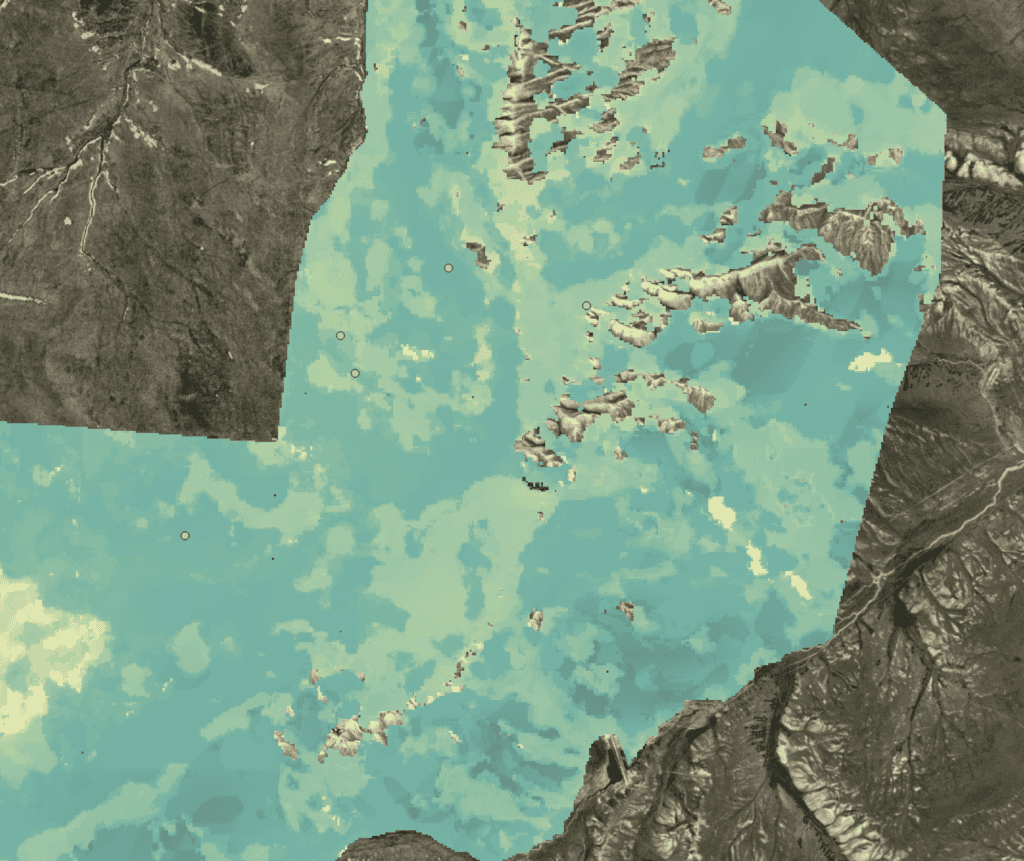
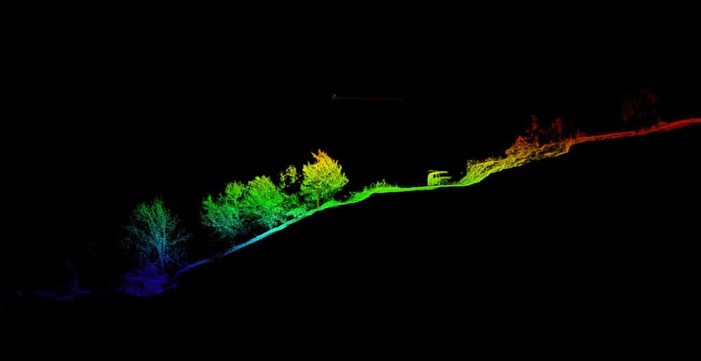
Image: Perennial’s SOCSPOT model is the highest spatial precision model of soil organic carbon we’ve seen.
Executing the Campaign: From Field Collection to Lab Processing
Execution is where theory meets the dirt. But before we leave the office, there is a lot of planning required. We map all of the roads, fences, water bodies, and even buildings. We remove all of the areas that are ineligible for carbon credits, like wetlands, urban areas, roads, or manmade objects. When we have a fully developed map of the site, then we can finally run the predictive models.
The predictive models can predict zones where soil carbon is most similar, using only remote sensing imagery. If we’re conducting a baseline, we’ll use deep learning fine-tuning to train the existing model with real sample data. From there, we perform preliminary stratified random point generation, without any prior samples to inform AI models.
Once we have a set of points, we plan the routes between points using the existing roads. This dramatically speeds up collection in the field, and also has the benefit of reducing soil compaction in the pastures from fewer vehicles driving.
At this point, we have the planning done for a pre-sampling campaign. Projects that use a pre-sampling campaign to refine the baseline are much more cost-efficient because the pre-sampling data allows us to understand soil variation much better, before we go to collect hundreds or even thousands of sites.
We load the points into our custom rTek LIMS, and the map is loaded into the mapping software aboard the vehicles. Backup maps are loaded onto the motorcycles’ equipment with handheld GPS units, so every person knows where to go. Points are often clustered, allowing our team to position a mobile base with a pickup truck and two motorcycles loaded on the back. The truck has emergency gear, Starlink, solar power, a refrigerator, and tools for core extraction on board- everything we need for extended stays 100 km away from the nearest village.
From the truck, the motorcycle operators drive solo into the pasture, up to 20 km away from the base, 100% off-road. Pastures in Kazakhstan are extreme, with strong topography, hidden coils of wire and metal scrap, and hazardous obstacles still remaining since the Soviet Union’s Virgin Lands Campaign. Operators also contend with snakes, high-UV and temperatures, and wild animals. Each motorcycle carries a full sampling toolkit and satellite communications equipment, so they can maintain a link with the base in case of an emergency.
At each site, rTek’s custom-designed sampling corer drives a 50 mm wide-diameter core down to 45 cm or bedrock, using a vibratory hammer. Each soil core is extracted fully intact—even in planted fields. Compared to small nutrient probes, 50mm cores are much harder to drill, but the additional accuracy is worth the effort.
Pasture soils can contain a high degree of natural variation in soil density- rocks, roots, and air pockets. In calcareous soils, up to 30 mm diameter chunks of limestone are common. These exclusions do not sequester soil carbon, so it is vitally important that they are captured and measured precisely.
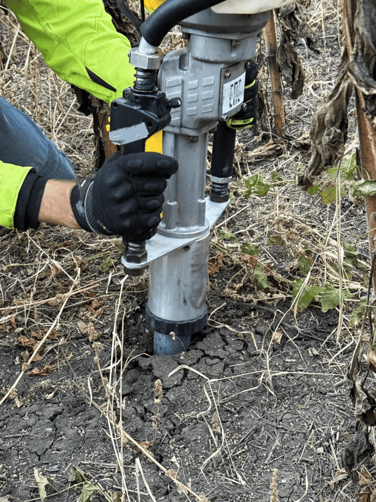
Our large diameter cores do just that. With it, we extract 1-2 kg of soil per sample and are able to accurately determine the soil’s density, within a few percent. It’s extremely important to get this bulk density measurement correct, as it is responsible for the over 3 billion times conversion from our elemental analysis sample (~0.3g) to the whole area each analysis represents (1 million tons of 0-30 cm soil).
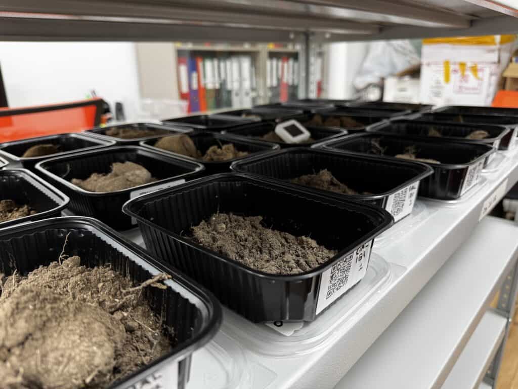
Sharpened steel cores produce a high-quality soil cylinder. With our sampler, the entire core is used, with a sleeveless design. The bottom of the core cuts the core cleanly at 45 cm. Operators store the cores capped and transport them back to the truck, where they are separated into 0-10 cm and 10+ cm depth horizons.
From there, the subsamples are loaded into 2-8°C refrigerators, where they remain until they are processed at the laboratory.
Ensuring Compliance and Quality: rTek’s Rigorous Standards
We adhere to Verra, ISO 10694 for carbon, ISO 11272 for density, and ISO 17025 for operation, at the KazNARU Soil Laboratory in Almaty. QA/QC (Quality Assurance/Quality Control) includes duplicates, round-robin with Brookside Lab (USA), usage of high quality standards and calibration, and rTek’s in-house LIMS for auditing.
Long-term consistency is key for any projects in the voluntary carbon market. That’s why rTek has established fist-of-its kind partnerships with key international companies.
Valor Carbon: rTek is partnered with Valor for brokerage of the highest quality carbon credits, targeting Verra VM0032 (Grassland Restoration), VM0042 (Integrated Agricultural Land Management), and Puro Earth Biochar. Our partnership with Valor assures that we can sell any credits we generate, and opens up unique pre-financing opportunities for projects just getting started.
Perennial: rTek has a long-term partnership with Perennial as its exclusive MRV provider in the soil carbon space. When you partner with rTek, you partner with the best full-service carbon project developers in central Asia.
FAO: rTek is supported by the Food and Agriculture Organization of the United Nations, including the GEF-7 program and several initiatives in Kazakhstan to restore rangeland soils using sustainable agriculture techniques.
The Bigger Picture: Benefits for Carbon Sequestration in Kazakhstan
We focus entirely on NbS (Nature-Based Solutions) Removals projects. Over the last couple of years, NBS have experienced a downturn in public reputation, tied together with REDD+ and sustainable energy pricing drops. But soil carbon is a different story.
Soil, although still not without risk, is one of nature’s most reliable tools for removing greenhouse gases from the atmosphere. When stimulated, not treated as a resource to extract, soil can regenerate, building up microbial life, nutrients, and water storage together.
Pasture soils have long been assumed to be unprofitable in Kazakhstan, compared to arable chernozems. Although arid soils are difficult to establish carbon, it is feasible, and represents an enormous opportunity for farmers to embrace new technologies like rotational grazing, access new revenue streams, and decrease risks of food and water scarcity region-wide.
Ready to Sample Smarter? Contact rTek Today
Stratified random sampling isn’t just a method—it’s a pathway to sustainable land management in Kazakhstan. At rTek, we’re making it accessible and effective.
We handle full-service sampling and testing for a variety of elements, from soil carbon to micronutrients. Contact us today – we’re excited get started on your project!